Putting Earth AI to work: Geospatial agents for our planet's biggest challenges
Google Research published a technical report on its Geospatial Reasoning agent, an experimental system that connects Gemini to Earth AI foundation models and planet-scale geospatial data, and said it is expanding early access through Ask Google Earth and an Agent-to-Agent service. The report was announced by Shravya Shetty, a Distinguished Engineer, and Luke Barrington, a Product Director, both at Google Research. The work builds on Google Earth AI, a suite of geospatial foundation models covering remote sensing, weather, flood hydrology and population dynamics that the company previously introduced alongside a Gemini-powered agent prototype. The new report presents systematic evaluations across four benchmarks, two of which Google developed and is releasing.
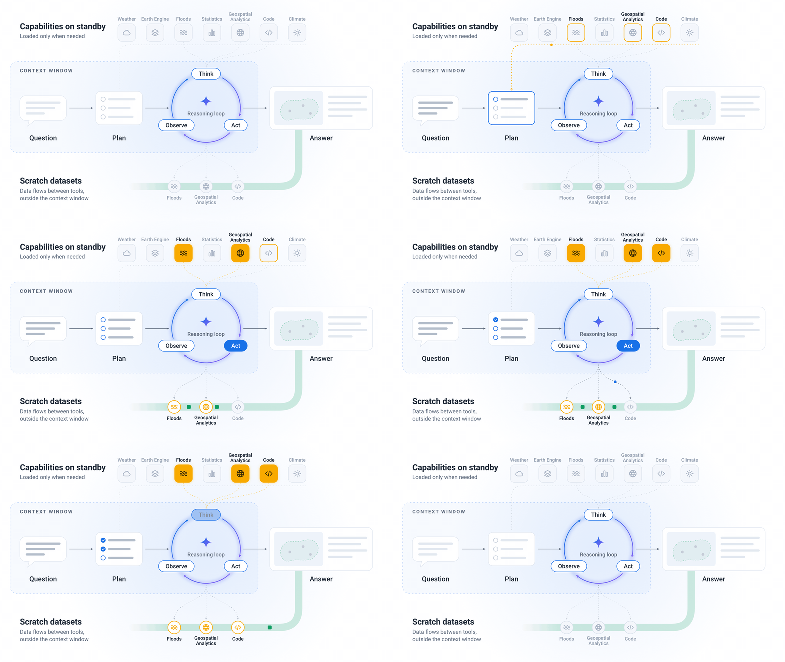
The agent is assembled from four capabilities. First, it connects Gemini to Earth AI models including WeatherNext, Flood Forecasting, the Population Dynamics Foundation Model (PDFM), AlphaEarth Foundations and Remote Sensing Foundations, and to sources such as Google Maps Platform (place information, routing, air quality, rooftop solar potential), Google Earth Engine, Data Commons and Google Dataset Search. Second, Earth AI capabilities are packaged as modular skills the agent calls only when a query needs them. Before running complex operations, the agent builds a step-by-step plan, selects fallback datasets when local coverage is sparse, and processes large map layers in a dedicated workspace rather than loading them into the model context. Each response shows the agent's plan and the data sources used, so experts can check assumptions or swap datasets. Third, users can bring their own data through the Geospatial Reasoning agent API as CSV spreadsheets, custom map boundaries in GeoJSON, or cloud tables, and ask the agent to join private locations with Earth AI's global models and catalogs. Fourth, the agent powers the previously announced Planetary Prediction Engine: given local outcome data such as regional disease rates, crop yields or grid outages, it selects relevant population and environmental signals, fuses Population Dynamics Insights and Custom Satellite Embeddings (Maps Platform products built on PDFM and AlphaEarth Foundations respectively), and trains validated machine learning models for spatial prediction, super-resolution downscaling and forecasting. In recent public health research, Google says combining these population and satellite signals improved predictions of health outcomes by 12% over demographic baselines and enabled mapping at 8X finer spatial resolution.
The evaluation compares four agent configurations across Gemini 3.8 Flash and Gemini 3.1 Pro: a standalone LLM, the LLM with basic web search and maps grounding tools, the LLM with Earth AI tools such as Remote Sensing Foundations and WeatherNext 3 but without upfront planning, and the full Geospatial Reasoning agent that starts every query with a dedicated planning stage. It spans four benchmarks. Two are externally developed: CBGB tests geospatial code generation and UnivEARTH tests question answering. Two are new and developed by Google: GeoExpertQueries introduces complex real-world queries with expert-authored golden workflows covering crisis resilience, site selection and public health, while GeoKTools contains templated queries with verifiable answers, each requiring correct selection and use of one to four distinct geospatial tools. Google is releasing the development splits of both new benchmarks in full.
Two findings stand out. Domain-specific skills matter: an agent with only web search, maps grounding and code execution struggles on quantitative spatial tasks, and adding Earth AI skills produces a significant jump across GeoExpertQueries, GeoKTools and CBGB, with the exception of UnivEARTH, where even a standalone LLM scores 93.6%, likely because the underlying NASA articles and answers are on the public web. Upfront planning matters for open-ended work: Earth AI skills alone suffice for narrower tasks like CBGB and GeoKTools, but open-ended GeoExpertQueries problems need planning to keep the agent on track across multi-step analyses and to stop it making unreliable assumptions or resorting to web search instead of spatial tools. Google reports scores on a 0-100 scale averaged over three runs, noting each benchmark is scored differently so comparisons should stay within a row.
Google also flags limitations. GeoExpertQueries scores come from an autorater that compares the agent's performance against expert workflows defining the steps an analysis should take, not the correct final answer, so Google considers the output a strong first draft for experts to review rather than a final answer.
Partner testing spanned social impact and commercial organizations: the WHO Regional Office for Africa, People in Need, GiveDirectly, the Milken Institute and WPP. At the start of the 2026 Ebola outbreak in the Democratic Republic of the Congo, WHO AFRO's Emergency Preparedness and Response Hub in Dakar used the agent to map remote mining corridors by cross-referencing forest loss from satellite imagery, mining sites from maps and web data, and population data; in minutes the team pinpointed 48 exposed settlements and more than 45,500 at-risk people, a process Google says would normally have taken weeks, allowing responders to deploy mobile laboratories and coordinate border surveillance. The DRC's National Institute for Biomedical Research used the Planetary Prediction Engine to estimate Ebola spread into uninfected zones by combining mobility flows with historical case trends. People in Need said the agent helped analyze 14 historical cyclone paths to identify high-exposure villages in minutes rather than days of manual GIS work. GiveDirectly uploaded custom map boundaries to calculate population exposure by wind-speed zones during Tropical Cyclone Maila and benchmark tornado damage in Mississippi, cutting crisis scoping from days to minutes. Milken Institute pre-development teams combined their own lists of more than 1,500 candidate buildings with Maps Platform's Solar API and census data to screen community resilience hub locations. Google says partner feedback drove recent additions including road-network routing, support for larger user-uploaded datasets and better discovery of authoritative local data sources.
Access is experimental and limited. Ask Google Earth gains a preview of expanded deep analysis, an interactive chat where users ask complex spatial questions in natural language, analyze data including their own in Google Earth projects, and see results on the map. Developer teams can request an experimental headless Agent-to-Agent service to connect the agent to custom agents and data pipelines, with developer recipes for Gemini for business environments. Planetary Prediction Engine capabilities are also in early preview via an interactive interface and the Agent API. Google directs interested parties to an interest form and its Early Access Pool.
Why it matters: the report's central claim is that packaging domain tools and an explicit planning stage beats prompting a general model, which is directly relevant to teams building agents over specialized data. For developers, the A2A route suggests geospatial reasoning will be wired into existing pipelines rather than used only through a chat surface, and the released benchmark splits give a way to compare approaches. Product teams in humanitarian, insurance, energy and marketing work should watch the measured gains (12% better health outcome prediction, 8X finer mapping) alongside the stated caveat that outputs are first drafts for expert review, which implies human validation stays in the loop. Access remains limited and experimental, so this is a signal about direction rather than a generally available product.
Based on reporting from the original publisher. Visit the source for full context and later updates.
Publisher excerpt
Earth AI